Empowering Customers with Data-Driven Solutions:
Visualize the Benefits of GIS
GIS captures, stores, analyzes, and presents data related to geographical locations and features to help users understand complex issues through maps, models, and simulations. PMI is a leading provider of GIS services, including data management, spatial analysis, and mapping. These services use cutting-edge technology to provide clients with accurate insights and are widely used in industries like urban planning, environmental management, and transportation.
Get the entire landscape of your next challenge with our GIS Services.
Our Geospatial Information Systems Capabilities
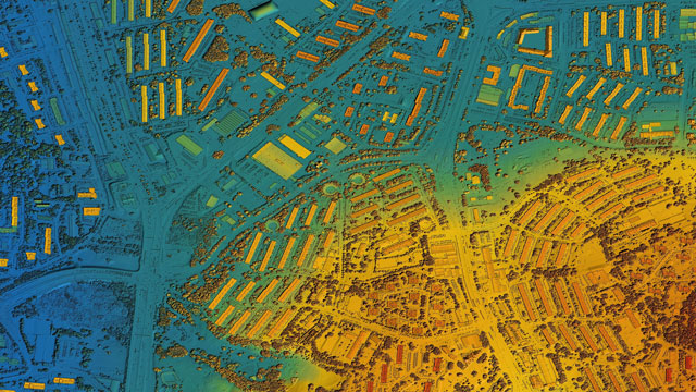
Geospatial Services
Geospatial services refer to satellite data processing , a technique in which the information on various map attributes, facilities, assets, and organizational data are digitized and organized on a target GIS system. Digital Photogrammetry Services & Remote Sensing services ensure accurate and cost-effective data collection which are important inputs for planning and designing of mapping projects.

Utility Mapping Services
The Utility Mapping process is used for the identification of buried pipes and cables beneath the ground. The procedure involves detecting sewers, electric cables, telecoms cables, gas mains, and water mains. Our topographical mapping services will provide you with a comprehensive detailed map of anything that is hidden underground or directly related to any above ground features.
GIS Navigation
GIS-based systems provide and analyze essential economic, demographic, and cost estimates for planning new routes. Road scanning helps in analyzing existing routes, collecting data, and informing travelers of changes to routes. Route planning, analyzing site areas, and calculating overall drive times assist in maximizing potential customer inflow and ensures the best possible accessibility.

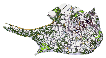
Urban Planning
Urban planning involves land use and land cover planning, environmental planning, transportation planning, zoning, and economic development planning. Land Surveying Services identify challenges connected to urbanization such as land-use conflict, destruction of natural ecosystems, traffic and vehicular congestion, and other hurdles. Asset mapping can help avoid and eliminate these hurdles, saving time and energy.

Natural Resource Management
Natural Resources Management benefits from CAD and GIS software to gather and represent data essential for forest mapping services, mining mapping services, hazard and risk assessment, change detection, and environmental monitoring. The technical specifications of geographic information systems (GIS) and computer-aided designing and drafting services enable foundations for sustainable decision-making.
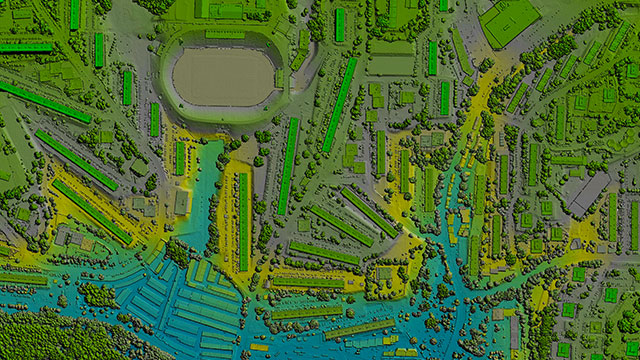
Mobile LiDAR Services
Mobile LiDAR is an innovative mapping solution that incorporates the most advanced LiDAR sensors, cameras, and position/navigation to collect survey-quality point data quickly and accurately.
LiDAR Mapping, Data Processing Services, and point cloud classification services extract information from buildings, vegetation, vehicles, and water to create 2D/3D objects in any GIS or CAD format at a competitive cost.
PMI GIS Advantages & Benefits
- Deliverables are provided quickly and at cost-effective rates
- Quality delivery executed per deadlines
- Manage overflow workload for on-time delivery
- Expand your team with our large resource pool
- Receive 24/7 support
- Reduction in overall operational costs
- Manage geographical data
- Accurately keep records and data history

Digital Mapping & Navigation Solutions
Digital mapping is the process by which a collection of data is compiled and formatted to produce maps to provide solutions for navigation and traffic.
Disaster & Emergency Planning
Emergency and disaster planning involves a coordinated, co-operative process of preparing to match urgent needs with available resources. With geospatial services these plans are accurately recorded.
Smart Cities & Community Development
GIS, Remote Sensing, and GPS play pivotal roles in the implementation of Smart City activities ensuring accuracy of Digital Twins to represent real world scenarios.
Traffic & Urban Planning
The increasing trend of urbanization, population, and number of registered vehicles on roads can cause traffic congestion problems which GIS can alleviate.
Accident & Hotspot Analysis
GIS-based techniques have led to improved traffic accident analysis by employing spatial statistics. This enables engineers and researchers to account for trends and variations in hotspot locations.
Telecom, Network, & IoT
GIS, geospatial data, and visualization and analyzing tools make it possible to develop an integrated system benefiting from real-time data collection and real-time monitoring provided by IoT.
Structural Asset Management & Maintenance
PMI combines powerful mapping and spatial analysis with a comprehensive system for organizing strategic asset information for utilities, energy, government, transportation, and other industries.
Environmental Impact Analysis
Environmental Impact Analysis (EIA) assessments are primarily guided by GIS solutions to ensure governing bodies and organizations monitor the impact of human activities have on environment and plan projects accordingly. Information provided with mapped layers and geospacial techniques present information visually with relevant data to inform decisions to comply with environmental legislation and reach intended goals.
Agriculture & Natural Resources
Mapping agriculture & natural resources can help to manage, preserve, and restore natural resources. Farming and agriculture benefits from GIS for topography, irrigation, and production yield.
Surveying, Topography, & Siting
A topographic survey collects information about the land's natural and man-made characteristics, as well as its terrain. Buildings, fences, trees, and waterways are permanent structures that accurately define the ground and its boundaries. The elevation of the terrain is depicted by land contours and spot levels.
Geology & Geographic Features
Geologic mapping is a highly interpretive scientific process that can produce a range of map products for many different uses. Land management and land use planning benefits from geologic mapping, as well as waste repository siting. Assessing ground-water quality and contamination risks, predicting earthquake, volcano, and landslide hazards, and characterizing energy and mineral resources and their extraction costs are also possible with geologic mapping.
Our Experts
PMI’s partnership with PMC has provided digitization and data services globally for over 30 years. Our teams’ GIS Services and expertise allows for our customers to efficiently visualize and manage geographic data, providing effective solutions.
Our GIS Partners
PMI is the authorized channel partner of Skymap Global for the USA, India, and the Middle East regions. Working together, we provide top-of-the-line GIS Services and GIS solutions to our clients.
What to expect when engaging a GIS Expert with PMI
Input Data Collection & Mapping:
GIS data collection is primarily carried out by satellites, aircraft, or drone imagery, providing characteristics of a location and other attributes in a workable format.
Data Analysis:
GIS analysis processes and methods help manage data and perform analysis that give a complete understanding of locations and surroundings which can be used for market research, risk management, demographic behavior, and consumer trends.
Data Processing and Conversion:
Geospatial data processing & conversion is the process of moving geospatial data from one format into another. More than half of the GIS projects today involve data conversion or migration from CAD to legacy GIS formats.
Data Updates:
Accurate data updates help to maintain and operate the base data. This exercise will ensure to avoid data duplication and data mismatch.
QA/QC Checklists:
QC can be performed in-process during production in the form of feedback. Early detection of errors and feedback are essential in successfully producing high-quality, cost-effective data.
Final Data Submission:
Final GIS Data submission occurs once all errors are rectified.

GIS services involve information being captured and analyzed to be presented in a digestible way. GIS technology organizes spatial data visually and provides specific and important insights such as resource knowledge, demographic trends, and utility mapping information. These technologies also help capture crucial data, allowing for improved hazard and risk assessment, detection of changes and environmental monitoring, as well as general analysis.
Industries that benefit from our GIS Services
Urban Planning
Smart Cities
Architecture
Engineering
Construction
Energy and Utilities
Renewables, Oil, and Gas
Telecommunications
Major Transit Systems
Aerospace & Airports
Manufacturing Site Planning
Warehouse Site Planning
Healthcare and Hospitals
Logistics & Supply Chain
Speak with one of our GIS Experts!
Send a message to our team by filling out the form below. Describe your project, ask questions, or even request a bid.
An expert from our team will be in touch with you within one business day!
Want to schedule a time to speak with one of our representatives NOW?